Thanks to the rover driving across the deposits, scientists can obtain up- close observations and detailed measurements of the rocks, similar to the field work done by geologists on Earth.
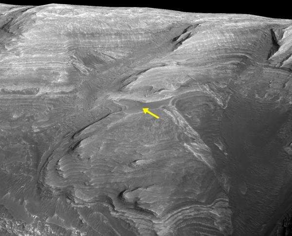
A new paper led by Catherine Weitz, Senior Scientist at the Planetary Science Institute, takes a new look at an enigmatic feature seen in orbital data of Mount Sharp, a 5.5 kilometer-high mound in Gale crater. Because the darker horizon can be distinguished from the surrounding brighter rocks, it can be traced across Mount Sharp and it marks a specific time period within the crater, which is why it is referred to as the Marker horizon.
The marker horizon appears to be either one or more rock layers or a zone of weathering with a different appearance from the sulfate-bearing rocks in which it occurs. Volcanic ash is a common marker horizon on Earth because it can appear different from the surrounding rocks and it can be traced across different landscapes. marker horizon is a time-stratigraphic feature that can be used to trace the marker horizon across large areas, so we can always know what rocks were deposited before or after it.
There was a different kind of rock unit that resulted from the deposition of sulfate-bearing sediments. The marker horizon is different from the sulfate-bearing rocks above and below it, indicating an environmental change occurred for a brief time, such as a drier period or an explosion from a nearby volcano that deposited ash across a large area.
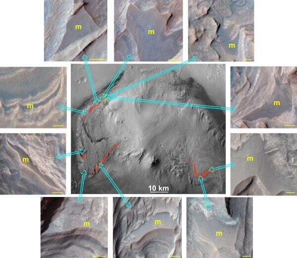
We used data from the Mars MRO to map out where the marker horizon occurs. We found that the marker horizon varies by 1.6 kilometers across Mount Sharp, that it dips between 1 and 5 degrees away from the center of Gale crater, and that it has a mafic composition similar to other basaltic materials.
We explored several different formation mechanisms for the marker horizon. It could be composed of the same materials as the sulfate-bearing rocks above and below it, but became harder and more resistant to erosion either during formation or later by water carrying minerals to cement it. The marker horizon could be a sandstone or lag deposit that formed when the crater was less wet. There is a chance that the horizon contains volcanic ash that was deposited when a nearby volcano exploded. All of these potential origins require the presence of at least some water to cause cementation that hardened the horizon.
The marker horizon is different from the nearby sulfate outcrops because of closer observations. The marker horizon is 700 meters away from the rover's location, crossing from the Greenheugh pediment to the clay-sulfate transition region. Weitz, a co-investigator on the HiRISE camera and a science team member, said that the exploration of the marker horizon would enable detailed analyses of the properties of the soil.
These in situ observations and measurements can be used to distinguish between the multiple proposed formation scenarios. It is possible that the origin of the marker horizon could be the result of something we did not anticipate from the data we collected.
More information: Catherine M. Weitz et al, Orbital Observations of a Marker Horizon at Gale Crater, Journal of Geophysical Research: Planets (2022). DOI: 10.1029/2022JE007211 Journal information: Journal of Geophysical Research: Planets Citation: Enigmatic rock layer in Mars' Gale crater awaits measurements by the Curiosity rover (2022, April 28) retrieved 29 April 2022 from https://phys.org/news/2022-04-enigmatic-layer-mars-gale-crater.html This document is subject to copyright. Apart from any fair dealing for the purpose of private study or research, no part may be reproduced without the written permission. The content is provided for information purposes only.All Rights Reserved © 2024


