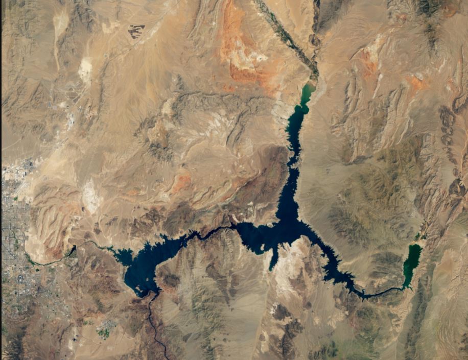
How severe is the drought in western United States? Images of Lake Mead, a reservoir created by the Hoover Dam on Colorado River, show the extent of the drought. Below are satellite images from NASA Landsat 7 (and Landsat 8) that show the differences in lake levels between August 2000, August 2021, and August 2021.
Comparative Landsat satellite images from Lake Mead, August 7, 2000 (left), and August 9, 2021(right). NASA Credit
The U.S. Bureau of Reclamation reported that the water level in the reservoir, which supplies water to millions of people in California and Arizona, Nevada, and a part of northern Mexico, was at its lowest level since 1935, when the Colorado River was dammed.
According to data, Lake Mead had a capacity of just 35% as of August 22, 2021. This low water level occurs at a time when 95% of the West's land is under some degree of drought (64% is severe or worse). This megadrought, which has been ongoing for 22 years, may be the region's worst drought in 12 centuries.
This image is from 2021. It shows the tan fringes that run along the shoreline in 2021. These are areas of the lakebed which would be underwater if the reservoir was filled to its full capacity. This phenomenon is sometimes called a bathtub ring.
Below is data on the lake elevation. It shows that the Hoover Dam's water level at the end July 2021 was at 1067.65 feet (325m) above the sea level. This was the lowest elevation since April 1937 when the lake was still being filled. At the time of Landsat 7 images, the elevation was 1,199.97 feet (341 metres).
Data via NASA and the U.S. Bureau of Reclamation.
Lake Mead, at its maximum capacity, reaches an elevation of 1,220 feet (372m) near the dam. It would store 9.3 trillion gallons (36 trillion trillion liters) water. In the summers 1983 and 1999, the lake was at its maximum capacity. Since then, it has been falling.
Lake Mead, the United States' largest reservoir, is part of a water supply system that provides water for at least 40 million people. The record low levels in the reservoir means less water will be portioned out to some states in the 2022 water year, and the U.S. Bureau of Reclamation said that the reductions represent the first shortage declarationdemonstrating the severity of the drought and low reservoir conditions.
Sources and additional reading: NASA Earth Observatory, U.S. Bureau of Reclamation


