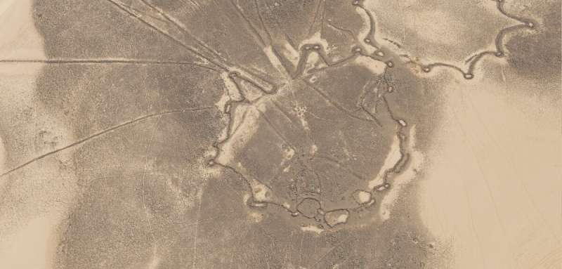
Satellite imagery has been used by archaeologists at the University of Oxford's School of Archaeology to identify and map more than 350 monumental hunting structures known as "kites" across northern Saudi Arabia and southern Iraq.
The team of researchers used a range of open-sourced satellite imagery to study the region around the eastern Nafud desert. Our understanding of prehistoric connections and climate change in the Middle East could be changed by the results of a recent study.
These structures are called kites because of the low stone walls that make up a head enclosure and a number of guiding walls. They are thought to have been used to guide the game into an area where they could be killed. Evidence shows that these structures may have been built in the Neolithic period.
Recent discoveries of new distributions have been made thanks to the advent of commercial satellite imagery and platforms. While these structures were already well-known from eastern Jordan and adjoining areas in southern Syria, these latest results take the known distribution over 400 km further east across northern Saudi Arabia.
There was evidence of complex, careful design in the structures we found. The heads of the kites can be over 100 meters wide, but the guiding walls of the kite can be very long. Some of the walls that are still standing run in almost straight lines for over four kilometers. The ability to design and build these structures is amazing.
It is believed that considerable resources would have had to be coordinated to build, maintain, and rebuild the kites over generations, together with hunting and returning butchered remains to settlements or camps. Their exaggerated scale and form may be an expression of their status. The appearance of kites in rock art in Jordan suggests they were an important part of the symbolic and ritual spheres of Neolithic peoples.
From the design of the kite heads to the careful runs of guiding walls over long distances, these structures contrast greatly in scale with any other evidence of architecture from the early Holocene period. According to the researchers, the builders of these kites used temporary structures made from organic materials that were not visible on satellite imagery data.
At the time they were built, these new sites suggested a previously unknown level of connection. Questions about who built these structures, who the hunted game were intended to feed, and how the people were able to not only survive, but also invest in these monumental structures were raised.
The distribution of star-shaped kites gives the first evidence of contact through the Nafud desert. This shows the importance of the areas that are now desert in allowing the movement of people and animals. The kites are thought to have been built during a time when the climate was cooler than it is today.
The largest number of kites were built on the Al Labbah plateau in the Nafud desert, where the lack of Bronze Age burial monuments suggests that some of these areas became too marginal to support the communities once using these landscapes.
Whether the patterns of kite construction over space and time represent the movement of ideas or people remains to be seen.
The project is extending its survey work across the now arid zones in order to better understand the effects of climate change.
The study looked at following the herds. There is a new distribution of hunting kites.
More information: Michael Fradley et al, Following the herds? A new distribution of hunting kites in Southwest Asia, The Holocene (2022). DOI: 10.1177/09596836221114290